- -- - -- - -- - -- - -- - -- - -- - -- - -- -

Art--Animals--Dates--Food--Links--Lists--Map--Movies & TV--Music--Nature--Places--Performances--Souvenirs--Structures--Timeline

Thursday 10 September 2015

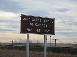
Longitudinal Centre Of Canada

Meet me in the Middle.

Location: Winnipeg, Manitoba, Canada
Address: Trans-Canada Hwy (MB-1) and (MB-206)
Date: Oct 2014

  Somewhere between the eastern edge of Newfoundland and the western side of British Columbia is the longitudinal centre of Canada.  We had flown to Winnipeg, Manitoba and when we heard that the longitudinal centre of Canada was a short drive to the east, we set out for a drive.  We did this despite the fact that our actual destination was in Saskatchewan to the west.  The drive took us about 20 minutes from Winnipeg until we reached the signs.  The nice thing about the Trans Canada Highway is that it is not very busy and the Manitoba terrain allows so that you can see the signs coming from quite a distance away.

Manitoba.
 
  There are actually two brown signs on each side of the highway.  Two on the east side and two on the west side so no matter which way you are headed you will pass them.  We slowed down with our camera ready and fired a few shots out the window.  Since we were headed west we had to head down the highway a bit for the next chance to turn around.  As we passed the signs again we fired away.  The end result is that the picture at the top of this post is the best one of the bunch.
  The reason that there are two signs is because Canada has two national languages, English & French.  That means there is one sign that reads Longitudinal Centre of Canada and another which says Centre Longitudinal du Canada.  We are not sure why they did not combine them into one sign with both languages as is usually the case.  Perhaps they could not agree on the actual spot.  Is it the first sign?  The second sign?  Or somewhere in between?  At any rate we drove past them all.
  The signs mark the point 96 degrees, 48 minutes of arc and 35 seconds of arc.  Don't be confused thinking that the ' and " mean feet and inches.  There does seem to be some debate as to if this is the actual spot, but we will trust the highway signs as they have always helped us get where we were headed.  Also debated is the exact centre of Canada.  This would be where the longitudinal centre meets the latitudinal centre.  Since the majority of Canada is unpopulated, this is located somewhere up in the territory of Nunavut. It is well above any of the provinces and not anywhere you could drive to.  We would place it roughly in line with the country of Iceland.
  Next time you are in Winnipeg, Manitoba or headed that way, maybe we will meet you in the middle.


Map of Our World
Longitudinal Centre of Canada

Post # 70

Sunday 30 August 2015

Neptune Diner

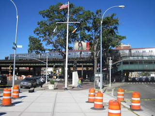
Neptune Diner tucked under Astoria Blvd. Subway Station.

Location: Queens, New York, USA
Address: 31-05 Astoria Boulevard
Date: Jan 2009
Website:  www.menupages.com

  One of our favourite places to eat in Queens, New York is the Neptune Diner.  We have always been treated very well by the hostess who greets you when you enter the restaurant.  The restaurant itself is nestled under the elevated Astoria Blvd. subway station and along with regular diner fare it specializes in Greek cuisine.  It is open 24 hours a day so it is always there when you need it.

Robert F Kennedy or Triborough Bridge.

  If you stay on Astoria Blvd. heading east past the diner, you will find yourself headed towards the Robert F Kennedy Bridge or more commonly known as the Triborough Bridge.  It was called the Triborough because it connects the three boroughs of Queens, The Bronx and Manhattan.

Columbus waits for the next N train to arrive.

  On the opposite side of Astoria Blvd. stands a statue of Italian explorer Christopher Columbus that was placed there in 1941.  The Neptune Diner, despite serving Greek food is also Italian based.  It is named after the Roman god Neptune who is the Italian version of Poseidon (God of the Sea).

Neptune Diner one of the best.

  After enjoying our meal at Neptune we say our goodbyes and it is just a short run from the front door and up the stairs to catch a subway into Manhattan for more New York City adventures.  We know the diner will be waiting for us no matter how late we return.

Neptune Diner right next to the Subway.


Map of Our World
Neptune Diner

Post # 69

Thursday 20 August 2015

Banyan Tree (Lahaina)

Under The Banyan.

Location: Lahaina, Hawaii, USA
Address: Courthouse Square, Front St.
Date: June 2010
Website:  lahainatown.com

  The banyan tree in Lahaina's main square was planted April 24, 1873 to commemorate the 50th anniversary of the first Christian missionaries in Hawaii.  It came from India where the banyan tree is the national tree.  As a seedling it was only 8 feet high.  When we finally arrived in Hawaii, it was over 60 feet high and covered an entire block.  Banyan trees are sometimes called strangler trees as they usually start their life on another tree and as the banyan grows it wraps its roots around the host tree.  As a banyan grows it also puts down roots from its branches.  This is why the tree in Lahaina appears at first glance to be several trees, but indeed it is just the one.  It also explains why the tree tends to grow outwards instead of upwards.

Panoramic Banyan.

  We spent some time admiring the tree as we waited for our whale watching tour to begin.  We also enjoyed some breakfast sandwiches at the appropriately named Banyan Tree Deli & Bakery across the street.

Banyan Tree Deli & Bakery.

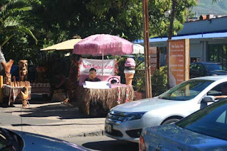
  As we walked along Front Street we also encountered a few characters.  There was a thinking captain in front of The Wharf Cinema Center and a Fred Flintstone in his car advertising ice cream at the Maui Swiss Cafe.

Hmm.  Which route shall we take?
Yabba Dabba Do you want some ice cream?

  The Courthouse Square where the banyan tree resides used to be the location of Lahaina Fort.  The fort was demolished and the courthouse was built well before the banyan tree arrived.  In the picture below you can still see some of the remnants of the fort behind the courthouse.

Remnants of Lahaina Fort.
Back of Courthouse.

    It is an impressive sight to see the tree that has taken over the square.  These days the tree is managed so that it does not encroach further into the courthouse or the surrounding streets.  It is still an impressive sight to see both by day or by night.  It also does a great job of providing shade and shelter from the Hawaiian sun.

Banyan by Day.
Banyan By Night.
 
  Finally it was time for us to head down to the harbour for our whale watching experience.  As the boat headed out to sea we looked back for one last glimpse of this impressive plant.

The Banyan Tree is in the dead center with a bit of the courthouse roof showing to the right.


Map of Our World
Banyan Tree (Lahaina)
Banyan Tree Deli & Bakery

Post # 68